使用cfgrib将数据保存为GRIB文件

Python

This article was last updated on <span id="expire-date"></span> days ago, the information described in the article may be outdated.

最近想要将导师的WRF工具包里的一些功能使用Python重写,因为想要使用优雅的方式实现,所以不可避免的涉及到了GRIB文件的读写。花了两天时间摸清楚了如何将数据写入GRIB文件,期间还遇到一些比较奇怪的问题。

使用cfgrib将数据写入GRIB文件

GRIB文件的读取是比较简单的,使用cfgrib.open_dataset或者cfgrib.open_datasets就可以将GRIB文件中的grib message读取成xarray.Dataset的格式。

但是GRIB文件的写入比较麻烦,需要设置一大堆的参数。通过查看cfgrib读取的数据,可以看到attrs里面有众多以GRIB_开头的属性,这里以我下载的ERA5 surface数据为例。

1
2
3
4
5
6
import cfgrib as cf
from pprint import pprint

ds = cf.open_datasets("surface.grib")[-1]
pprint(ds.attrs)
pprint(ds["skt"].attrs)
1
2
3
4
5
6
7
8
9
10
11
12
13
14
15
16
17
18
19
20
21
22
23
24
25
26
27
28
29
30
31
32
33
34
35
36
37
38
{'Conventions': 'CF-1.7',
'GRIB_centre': 'ecmf',
'GRIB_centreDescription': 'European Centre for Medium-Range Weather Forecasts',
'GRIB_edition': 1,
'GRIB_subCentre': 0,
'institution': 'European Centre for Medium-Range Weather Forecasts'}
{'GRIB_NV': 0,
'GRIB_Nx': 321,
'GRIB_Ny': 201,
'GRIB_cfName': 'unknown',
'GRIB_cfVarName': 'skt',
'GRIB_dataType': 'an',
'GRIB_gridDefinitionDescription': 'Latitude/Longitude Grid',
'GRIB_gridType': 'regular_ll',
'GRIB_iDirectionIncrementInDegrees': 0.25,
'GRIB_iScansNegatively': 0,
'GRIB_jDirectionIncrementInDegrees': 0.25,
'GRIB_jPointsAreConsecutive': 0,
'GRIB_jScansPositively': 0,
'GRIB_latitudeOfFirstGridPointInDegrees': 60.0,
'GRIB_latitudeOfLastGridPointInDegrees': 10.0,
'GRIB_longitudeOfFirstGridPointInDegrees': 80.0,
'GRIB_longitudeOfLastGridPointInDegrees': 160.0,
'GRIB_missingValue': 3.4028234663852886e+38,
'GRIB_name': 'Skin temperature',
'GRIB_numberOfPoints': 64521,
'GRIB_paramId': 235,
'GRIB_shortName': 'skt',
'GRIB_stepType': 'instant',
'GRIB_stepUnits': 1,
'GRIB_totalNumber': 0,
'GRIB_typeOfLevel': 'surface',
'GRIB_units': 'K',
'GRIB_uvRelativeToGrid': 0,
'long_name': 'Skin temperature',
'standard_name': 'unknown',
'units': 'K'}

这些GRIB_开头的属性即从GRIB文件中转换得到的参数,也是想把数据写成GRIB文件时所需要设置的参数。其中有一些参数是非常关键的:

  • GRIB_centre:GRIB文件只记录了编码后的信息,解码时需要对照码表文件将文件中的编码翻译为对应的信息,而不同的机构会有自己定义的码表。GRIB_centre这个参数即定义了编码和解码时使用哪个机构定义的码表。所有机构的定义可以在这里查阅。
  • GRIB_edition:GRIB文件有GRIB1和GRIB2两个版本,这两个版本间存在字段定义的区别,设置不同的版本会导致文件记录的信息不一致,这个问题稍后会提到。
  • GRIB_paramId:记录的变量对应的ID号,可以在这里查看ECMWF所有的ID定义。

也有一些参数是不用手动设置的:

  • GRIB_missingValue:无论你定义的值是多少,cfgrib软件包内部都会将这个数值重新设置

要想保证数据准确无误的写进GRIB文件,其他参数当然也是必不可少的,但是这里就不再展开说明了。

下面直接以一个示例来说明,如何将数据写入GRIB文件。

1
2
3
4
5
6
7
8
9
10
11
12
13
14
15
16
17
18
19
20
21
22
23
24
25
26
27
28
29
30
31
32
33
34
35
36
37
38
39
40
41
42
43
44
45
46
47
48
49
50
51
52
53
54
55
56
57
58
59
60
61
62
63
64
65
66
67
68
69
import cfgrib as cf
from cfgrib.xarray_to_grib import to_grib
import numpy as np
from xarray import DataArray, Dataset
from pandas import to_datetime


if __name__ == '__main__':
# 生成假数据
data = np.random.randint(280, 303, (2, 10, 10))

# 定义一个DataArray变量,并顺便定义GRIB参数
data_array = DataArray(
data=data, dims=["time", "latitude", "longitude"],
coords={
"time": to_datetime(["2020-01-01 00:00", "2020-01-01 01:00"]),
"latitude": np.arange(10, 0, -1),
"longitude": np.arange(0, 100, 10)
}, attrs={
"units": "K",
"long_name": "Sea surface temperature",
"standard_name": "Sea surface temperature",
# The following keys and values will be used in GRIB.
"GRIB_paramId": 34, # sst在ECMWF的GRIB码表中的ID是34
"GRIB_shortName": "sst", # shortName应确保是正确对应的
"GRIB_units": "K", # units应确保是正确对应的
"GRIB_name": "Sea surface temperature", # name应确保是正确对应的
"GRIB_stepUnits": 1,
"GRIB_stepType": "instant",
"GRIB_gridType": "regular_ll", # 投影方式,regular_ll代表等经纬度投影
"GRIB_iDirectionIncrementInDegrees": 10, # 经度方向格点间隔,这个值的正负和下面的iScanNegatively相关。
"GRIB_iScanNegatively": 0,
"GRIB_jDirectionIncrementInDegrees": 1, # 纬度方向格点间隔,这个值的正负和下面的jScanPositively相关。
"GRIB_jScanPositively": 0,
"GRIB_latitudeOfFirstGridPointInDegrees": 10, # 区域的经纬度起始点数值
"GRIB_latitudeOfLastGridPointInDegrees": 1, # 区域的经纬度起始点数值
"GRIB_longitudeOfFirstGridPointInDegrees": 0, # 区域的经纬度起始点数值
"GRIB_longitudeOfLastGridPointInDegrees": 90, # 区域的经纬度起始点数值
"GRIB_Ny": 10, # 纬度方向的格点数
"GRIB_Nx": 10, # 经度方向的格点数
"GRIB_typeOfLevel": "surface", # 变量的level类型
# The following keys and values can't be found at ECMWF websites.
"GRIB_cfName": "unknown",
"GRIB_cfVarName": "sst",
"GRIB_dataType": "an", # Analysis data, defined at https://codes.ecmwf.int/grib/format/mars/type/
"GRIB_gridDefinitionDescription": "Latitude/Longitude Grid",
"GRIB_numberOfPoints": 100, # 每一时刻数据场的总格点数,也就是 Nx * Ny
"GRIB_totalNumber": 0,
"GRIB_uvRelativeToGird": 0
}
)

dataset = Dataset({
"sst": data_array
}, attrs={
"GRIB_centre": "ecmf", # 定义使用哪个机构的码表
"GRIB_edition": 1 # 定义GRIB版本号
})

to_grib(dataset, "data/sst_test.grib")

ds = cf.open_dataset("data/sst_test.grib")
sst = ds["sst"]

print(np.where(data_array.to_numpy() != sst.to_numpy()))
print("")
pprint(ds.attrs)
print("")
pprint(sst.attrs)
1
2
3
4
5
6
7
8
9
10
11
12
13
14
15
16
17
18
19
20
21
22
23
24
25
26
27
28
29
30
31
32
33
34
35
36
37
38
39
40
41
42
43
44
45
(array([], dtype=int64), array([], dtype=int64), array([], dtype=int64))

{'Conventions': 'CF-1.7',
'GRIB_centre': 'ecmf',
'GRIB_centreDescription': 'European Centre for Medium-Range Weather Forecasts',
'GRIB_edition': 1,
'GRIB_subCentre': 0,
'history': '2024-09-23T21:21 GRIB to CDM+CF via '
'cfgrib-0.9.14.1/ecCodes-2.37.0 with {"source": '
'"data/sst_test.grib", "filter_by_keys": {}, "encode_cf": '
'["parameter", "time", "geography", "vertical"]}',
'institution': 'European Centre for Medium-Range Weather Forecasts'}

{'GRIB_NV': 0,
'GRIB_Nx': 10,
'GRIB_Ny': 10,
'GRIB_cfName': 'unknown',
'GRIB_cfVarName': 'sst',
'GRIB_dataType': 'an',
'GRIB_gridDefinitionDescription': 'Latitude/Longitude Grid',
'GRIB_gridType': 'regular_ll',
'GRIB_iDirectionIncrementInDegrees': 10.0,
'GRIB_iScansNegatively': 0,
'GRIB_jDirectionIncrementInDegrees': 1.0,
'GRIB_jPointsAreConsecutive': 0,
'GRIB_jScansPositively': 0,
'GRIB_latitudeOfFirstGridPointInDegrees': 10.0,
'GRIB_latitudeOfLastGridPointInDegrees': 1.0,
'GRIB_longitudeOfFirstGridPointInDegrees': 0.0,
'GRIB_longitudeOfLastGridPointInDegrees': 90.0,
'GRIB_missingValue': 3.4028234663852886e+38,
'GRIB_name': 'Sea surface temperature',
'GRIB_numberOfPoints': 100,
'GRIB_paramId': 34,
'GRIB_shortName': 'sst',
'GRIB_stepType': 'instant',
'GRIB_stepUnits': 1,
'GRIB_totalNumber': 0,
'GRIB_typeOfLevel': 'surface',
'GRIB_units': 'K',
'GRIB_uvRelativeToGrid': 0,
'long_name': 'Sea surface temperature',
'standard_name': 'unknown',
'units': 'K'}

numpy的输出表示读出的数据都是相同的,同时可以看到解码得到的属性值与我们设置的是相同的,同时cfgrib还为我们添加了一些对应属性的设置,例如GRIB_centreDescriptionhistoryGRIB_missingValue等。

坑人的问题

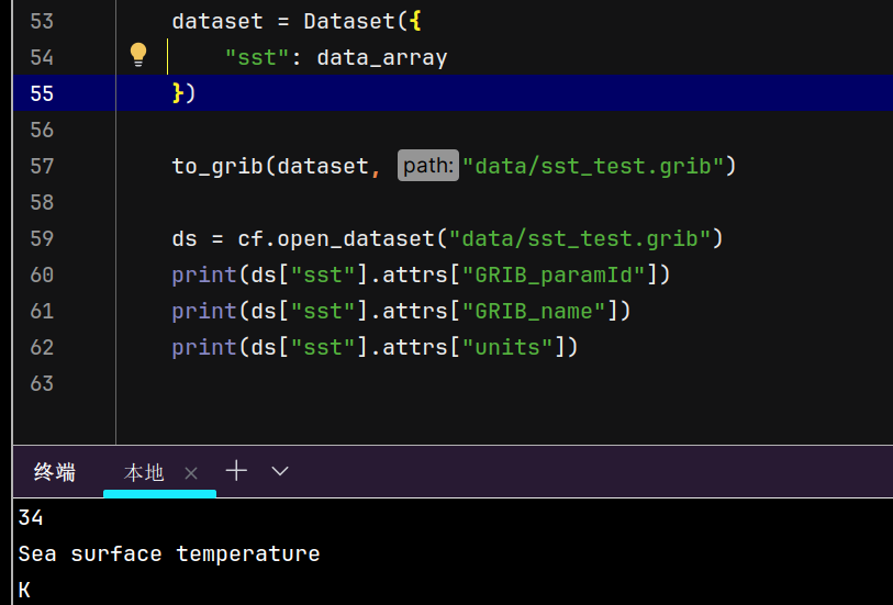
前面说道,GRIB_edition设置不同的版本会导致文件记录的信息不一致,起初我还以为这是cfgrib或者eccodes的bug,但是后来才发现是我对GRIB理解不足导致的。直接来看代码。

还是使用上面的例子定义的data_array变量,只不过这次我们对dataset.attrs的设置有所不同。

1
2
3
4
5
6
7
8
9
dataset = Dataset({
"sst": data_array
}, attrs={
"GRIB_centre": "my_centre", # 换成一个自定义的centre名称
})

dataset = Dataset({
"sst": data_array # 干脆不设置attrs
})

这两个dataset写入GRIB以后,读取出来的信息是不一样的。

image-20240923213439537 image-20240923213728691

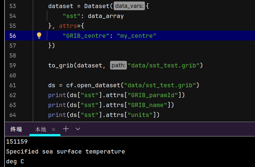
一开始我是想自定义GRIB_centre的名称的,因为我并没有想到GRIB_centre会影响到文件的解码,所以了解了GRIB_centre的用途之后,自然也就想到了这有可能是GRIB_centre设置不正确影响的,但其实不是的。my_centre并不是一个有效的机构名称,cfgrib会自动进行纠正。

image-20240923214754041

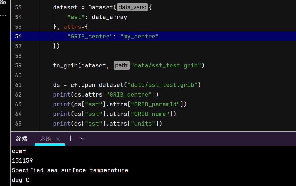
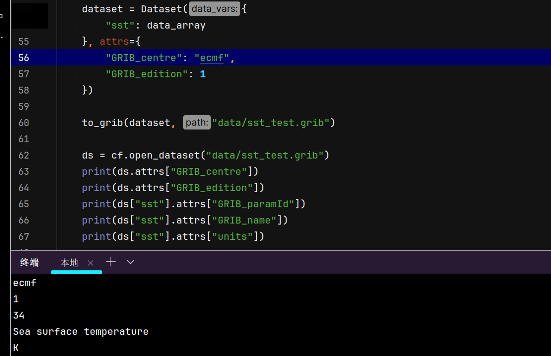
ecmf也是我下载的数据中GRIB_centre的设置,这说明并不是GRIB_centre导致的这个不同。这其实是GRIB_edition设置导致的,缺省情况下,cfgrib会以GRIB2的格式来写数据,而GRIB2和GRIB1的差异导致了我们写入和读取出的信息的不同,手动设置版本为1后,这个问题就可以解决了。当然为了规范期间,GRIB_centre还是设置一个有效的名称更好。

image-20240923215228915

Author: Syize

Permalink: https://blog.syize.cn/2024/09/23/write-grib-with-cfgrib/

本博客所有文章除特别声明外,均采用 CC BY-NC-SA 4.0 许可协议。转载请注明来自 Syizeのblog

Comments